


April is when the drift ice melts away from the Sea of Okhotsk. The trees in the forest slowly shift resources to growing their leaves, and in the now thawed swamps the yellow flowers of "ezono ryuukinka" (Hokkaido's marsh marigold species), and more heralding the arrival of spring. In the rivers, hatched salmon and trout fry will begin their battle to survive as they head to the sea. In May, many killer whales arrive in the Nemuro Strait, followed by huge flocks of short-tailed shearwaters coming from the Southern Hemisphere.
 Killer whale pod with Kunashiri Island in the background (June Photo)
In the summer as the darkening greenery of the primeval forest thickens, wild animals are in the middle of raising their babies. The Hokkaido sika deer, brown bears, and Ezo red foxes often appear with their offspring. On the oceans, you may be able to encounter killer whales, dolphins and sperm whales. In late August, brown bears appear near the shorelines, honing in on the salmon and trout run as the fish head upstream for spawning. This is also the peak season when tourists visit and Mt. Rausu and the Shiretoko mountain range will start the mountain climbing season.
 Brown bear catching masu pink salmon (August Photo)
From the Shiretoko Pass, you can enjoy the autumn colors of maples (Acer japonicum/hauchiwakaede) and Japanese rowan (nanakamado) that decorate the base of Mt. Rausu. Around the forest, you can often hear the peculiar cry "rutting call" of the male sika deer during the breeding season, as well as see the males chasing the females. Also, in September, the river is blackened with spawning pink salmon. The chum salmon run is slightly delayed and peaks in October.
 Masu pink salmon going upstream
The longest season of the year, winter. Around late January, the drift ice that emerged from the Amur River is pushed into the Shiretoko Peninsula with northwesterly winds, abundant with plankton and fish, then attracted to that come the white-tailed eagles and Steller's sea eagles to feed on them. Midwinter, both the rising sun from Kunashiri Island, and the setting sun over the expanses of Okhotsk drift ice, showers the silver snowy world in a majestic golden light, as though they are brilliant flames.
 Steller's sea eagle and white-tailed eagle standing on the drift ice
*The sunrise and sunset times are the average time around the middle of each month. Please use it as a guide.

The Shiretoko Peninsula is a land that was created by the seafloor being pushed up resulting from the submarine volcanic activity, beginning about 8.6 million years ago. About 4-5 million years ago when the Pacific Plate collided with the North American Plate (includes Hokkaido, also known as the Okhotsk Plate), and caused the Pacific plate to subduct beneath the North American Plate. Then about 1 million years ago, almost the entire current peninsula has moved Eastward, as it was raised up to be a land. Due to the onshore volcanic activity that has continued from about 250,000 years ago to the present, the Shiretoko mountain range such as Mt. Rausu and Mt. Io was born, and most of the present Shiretoko Peninsula was formed.
The subsea volcano which formed the Shiretoko Peninsula continued its volcanic activity even after it became an uplifted onshore volcano. Tens of thousands of years ago, the old volcanic materials were slowly covered up by new layers of lava. The older lava strata from the original submarine volcanoes is brittle and easily weathered away, while new lava from on land volcanoes is harder and stronger. This makes the topography of the tip of Rausu peninsula very different from that of Utoro and the central part of the peninsula.

There are many unique rock formations with names such as "Shishi-iwa" (Lion rock) "Kabuto-iwa" (Helmet Rock) and "Aka-iwa"(Red Rock) on the Shiretoko Peninsula. These naturally formed shapes come from old, fragile base of a submarine volcano slowly eroded by rainfall, waves and the drift ice impact, as well as hard rocks that are not that easily eroded. Rocks and cliffs made from these geological relics also serve as nesting sites for seabirds. Close observation of the Shiretoko Peninsula from the sea on a cruise boat, many examples of the volcanic activity can be seen.
 Rocks that are breeding grounds for seabirds

The Rausu fishery began in the latter half of the 18th century when merchants began full-scale development of the fishing grounds. At that time, "Nishin" herring, "Shirozake" chum salmon and "Karafutomasu" pink salmon were mainly processed into salted pickle and fishmeal and then sent to Honshu, mainland Japan. Currently, in addition to salmon and trout with fixed-net fishing along the coast, the fishermen use the Nemuro Strait where the deep sea fishing is only several kilometers offshore, to gillnet for Kichiji rockfish (locally other species called "menme" & "kinki"), "Hokke" Okhotsk atka mackerel and for "Suketoudara" Alaska pollock. Other fisheries such as squid fishing, kelp farming and sea urchin cultivation are also active as well. Unlike the Utoro side, the drift ice moves around on the Rausu side, so it is known as a "fishing castle town" that is bustling with fishing activity all year around, even in the winter.
 Fishing in Rausu, even in the winter
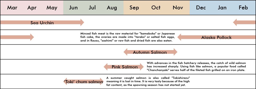
Rausu kelp includes naturally growing kelp and farmed kelp. Rausu's wild kelp harvest is carried out from mid-July to late August from 6 am to 11 am annually. Using box glasses to peer into the water, a forked rod called "makka" is used to harvest the kelp by entangling it in the rod and pulling it up carefully. In famed kelp, kelp seedlings are attached to a rope, which are submerged in the sea and grown for about 2 years, to 1 to 3 m before being harvested. Natural kelp is mainly used as high-grade soup stock, and the farmed kelp is used as kelp rolls and as Japanese sweets. Rausu kelp is world-class because it is grown in the nutritious seawater of Shiretoko and undergone a laborious process after harvesting, and it is famous as a high-class product with a rich aroma and umami flavor. Not only that, but the sea urchins that eat this nutritious Rausu kelp are also evaluated as high-quality products.
 Harvesting the wild kelp
| Japanese name | Oni Konbu |
| Scientific name | Saccharina diabolica |
There are many different types of kelp. "Rausu kelp" is the product name but the scientific name is "Oni-konbu." Since there are individual differences depending on the region, the kelp harvested in the Rausu region is called "Rausu kelp." It is very long at 3 meters in length and sometimes grows even longer. The kelp forest that covers the seabed acts as a great habitat for growing young fishes.
 Kelp that covers the seabed like a forest
 In the days when boats were rowed by hand, and travel took a long part of the day, the "Banya" hut was used as a workshop and for overnight stays during the kelp harvesting and fish run seasons. There are many banyas that are no longer in use, but they are still indispensable for Shiretoko fishermen.
In particular, the Akaiwa district, which is near the tip of the Shiretoko Peninsula, is said to have been so crowded that there were more than 50 kelp banya. It was said that the community even held August Obon festival dances there. During the summer, which is the fishing season, the whole family worked together and performed repetitive tasks such as harvesting kelp, laying it out to dry and other manually laborious work from early in the morning. Due to the influx of machine equiptment and rapid advances in technology, the last two Akaiwa banya finally closed in the summer of 2017. Nowadays, only abandoned houses remain in the Akaiwa area, but remain as monuments to the persevering generations before who continued to support Japanese food culture, on the farthest beaches without any power, infrastructure or even radio waves.

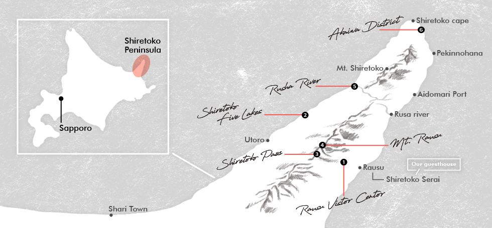
❶ Rausu Visitor Center
The Rausu Visitor Center is a facility set up by the Ministry of the Environment to highlight the connections between people and nature. Through exhibits & videos that explain the nature, history and culture of Shiretoko, visitors get to know more about Shiretoko National Park and responsible ways to enjoy it. In addition to the exhibits, there are also interesting taxidermies of brown bears, sika deer and even a whole body skeleton of a killer whale that died in the drift ice at Aidomari Port in 2005. Interpretive panels that explain the origins of Shiretoko, fisheries and the winter drift ice are on display as well.
(Rausu Visitor Center Website http://rausu-vc.jp/) A memorable skeleton of an entire Killer whale.
❷ Shiretoko Goko (Five) Lakes
A beautiful virgin forest is surrounded by 5 fantastic lakes. Throughout the year you can enjoy the views from the observation deck of the elevated boardwalk, overlooking a large panorama of Lake Daiichi and the Shiretoko mountain range. On sunny, still days you can enjoy the "mirror effect" of the lake reflecting the mountains. When walking on the boardwalk, visitors my come across sika deer peeking through the gaps in the bamboo.
 Shiretoko Goko (Five) Lakes
❸ Shiretoko Pass
At an altitude of 738m, this pass runs along the ridgeline of the Shiretoko mountain range and at the top, intersects Shari Town Utoro and Rausu Town. It is also very popular as a driving course and you might see the white of snow even in late July. In addition, the autumn colors of Mt. Rausu seen from here are spectacular. If the weather is good enough, the northern territory of Kunashiri Island could be visible as well.
 Shiretoko Pass and Kunashiri Island in the distance
❹ Mount Rausu
At an altitude of 1661m, this is one of the 100 famous mountains in Japan. There are two trailheads for Mt. Rausu, the Iwaobetsu trailhead (Shari Town side) and the Rausu Onsen trailhead (Rausu Town side). Since the name of the mountain is "Rausu," one might assume to start climbing from the Rausu town side, but it is more common to climb from the Iwaobetsu trailhead (Iwaobetsu route) on the Shari town side. The Rausu Onsen route is a course for advanced climbers. The guideline for the course time to the summit is 8 more than hours for the round trip on the Iwaobetsu route and it is recommended to prepare for 11 hours or more for the round trip on the Rausu Onsen route. The full-scale mountain climbing season starts in early July, but please note: Due to leftover snow deposits in July, it is difficult to stay on the route, especially for first-timers. Mount Rausu
❺ Rusha River
The Rusha River outflow into the ocean along the coast is a point where brown bears are often seen and occasionally a mother and her cubs might appear. It is a common spot to catch photographs of fishermen preparing their nets with brown bears walking near them. The wind strongly blows consistently from the Rusa (Rausu side) of the River. The name "Rusa" originated from the Ainu word "Ru e san i" which means "the road connects from there to the beach." It is said that the Ainu traveled along this river from east to west and traveled back and forth on the peninsula as a "road." Later, Ruesani was simplified to "Rusha." From the Shari side it is called "Ru-sha" and "Ru-sa" on the Rausu side. Banya near the Rusha river
❻ Akaiwa Area
There is a small cresent shaped beach at the tip of the Shiretoko Peninsula. On the beach, only about 2km long, you can see a "Banya" wooden hut which was once used as a fishing camp. Brown bears often appear in this area, and sometimes from a sightseeing ferry you can have a good look. When our staff visited nearby this site, they could see a brown bear walking on the slope near the coast, just before the Akaiwa area (Aidomari side). Red rocks (Akaiwa), the origin of the district name, and a brown bear walking by an abandoned banya


